[ad_1]

On Feb. 9, Northern California was drenched by a massive storm system; darker blues show more rain or snow.
Peter Aldhous for BuzzFeed News / Via disc.gsfc.nasa.gov
Last winter, the parched state of California braced for floods, high winds, and mudslides, as the strongest El Niño in nearly two decades roiled the Pacific Ocean.
Big storms hit the state in 1983 and again in 1998, during the two previous big El Niños — a pulse of warm surface water in the eastern Pacific that disrupts weather on both sides of the ocean.
But in 2016, the drought held.
This year, conditions were supposed to swing into a strong La Niña — the opposite of an El Niño — bringing cool surface waters to the eastern Pacific and dry conditions to the Golden State. Instead, California has been battered by storm after storm.
The massive Oroville Dam, some 75 miles north of the state capital, Sacramento, couldn’t cope. Last weekend, with the dam’s emergency spillway nearing failure, some 200,000 people were evacuated from their homes.
Flood waters spill from the Oroville Dam.
What is going on?
Experts say that the conventional wisdom of how El Niño and La Niña affect California’s weather is an oversimplification. In reality, the amount of rain and snow that falls on the Golden State in the winter months depends upon chaotic shifts in atmospheric conditions over the Pacific Ocean that are very hard to predict.
This year, the expected La Niña barely flexed its muscles before fizzling out. Storms that would normally have lashed the Pacific Northwest have drifted south, and dragged with them atmospheric rivers of warm moist air drifting up from around Hawaii — a phenomenon called the “Pineapple Express.”
The result has been a succession of lengthy storms that have seen parts of the state experience more than three times their average rain and snow.
What’s unclear is whether the extremes of the past few years have anything to do with global warming: In a system as chaotic as California’s winter weather, it’s hard to distinguish a signature of climate change from the normal variation.
But in general, climate models predict greater extremes of both drought and flood. And that’s bad news for a state that already has big problems managing its water supplies with a creaking infrastructure of dams, levees, and aqueducts.
California’s precipitation is the most variable, year-on-year, of any state in the nation.
Not only does the Golden State get almost all of its rain and snow between November and March, but the majority also tends to fall in a few heavy storms, occurring over just five to ten days. So if just a couple of major storms drift north or south, it makes a huge difference.
“The devil is in the details,” Nick Bond of the University of Washington in Seattle, who is also the state climatologist for Washington, told BuzzFeed News,
The generalization that El Niños are wet and La Niñas are dry does have some truth — at least for Los Angeles and the rest of Southern California. But in the San Francisco Bay Area, inland to the mountains of the Sierra Nevada, and in the north of the state, the amount of rain and snow that falls each year is pretty much a crapshoot.
“It’s only down south that El Niños tilt the odds significantly,” Mike Dettinger, a hydrologist with the US Geological Survey in Carson City, Nevada, told BuzzFeed News.
This year’s parade of storms became more likely once the expected strong La Niña wimped out, officially ending last week. “The absence of El Niño or La Niña opens the door for pretty wild weather,” Bill Patzert, a climatologist at NASA’s Jet Propulsion Laboratory in Pasadena, California, told BuzzFeed News.
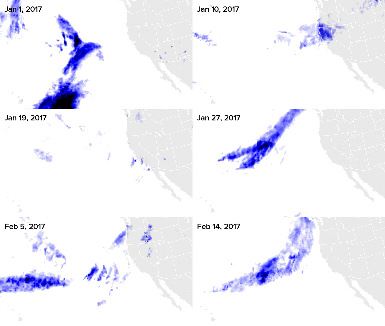
Since the New Year, storm after storm has pounded the state.

Darker blues show more rain or snow.
Peter Aldhous for BuzzFeed News / Via disc.gsfc.nasa.gov
What tipped things over the edge this winter was the Pineapple Express. This phenomenon has its origins in the waters of the tropics, where the trade winds from the Northern and Southern Hemispheres meet.
This Inter-Tropical Convergence Zone brews storms that can then drift to the north and south. Those moving north can form belts of moist air that barrel toward the US — especially if they get caught up with storm systems originating in the northern Pacific. It’s called the Pineapple Express because these atmospheric rivers tend to flow from around Hawaii.
Climatologists can’t yet tell whether California’s droughts and floods are getting more extreme.
Climate models predict that the Southwest US will get drier while the Northeast gets wetter. But Central and Northern California lie in a transition zone where it’s hard to predict exactly what will happen.
However, a warmer atmosphere can hold more moisture, which in general means that storms are likely to get heavier. More heat also likely means more droughts.
“You simply get more bang for your buck than you used to,” Kevin Trenberth, a climatologist at the National Center for Atmospheric Research in Boulder, Colorado, told BuzzFeed News.
The other danger for California is that global warming means more of its precipitation will fall as rain, and less as snow. That’s bad news, because it means that storms immediately threaten flooding, rather than boosting a snowpack that slowly melts to help the state through the dry summer months.
A sudden large amount of winter rainfall is what triggered the crisis at the Oroville Dam. “This is what we expect to see climate change serving up to us more often,” Dettinger said.
Now storms are battering the state once again. A major storm is expected to hit Southern California on Friday, threatening the heaviest rain event in six years.
LINK: California Scrambles To Make Repairs At Tallest Dam In The US After Evacuations Ordered
LINK: Yep, 2015 Was The Hottest Year Ever — Here’s Why
LINK: Look At These Maps, Then Prepare For Decades Of Droughts And Floods
[ad_2]
